Showing 254 items matching princes highway
-
 Orbost & District Historical Society
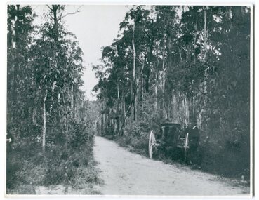
black and white photograph, 1913
... princes-highway-genoa transport... on the road between Genoa and the border - now the Princes Highway....on back - " Princes Highway showing the regrowth.....1913"... of it. on back - " Princes Highway showing the regrowth.....1913 ...This photograph shows the regrowth of vegetation on the road between Genoa and the border - now the Princes Highway.This is a pictorial record of the main road from Orbost to the New South border, The Princes Highway, in the early 20th century.A large black / white photograph of a bush road wwith a vehicle and a man on the side of it.on back - " Princes Highway showing the regrowth.....1913"princes-highway-genoa transport -
 Orbost & District Historical Society
black and white photograph, February 1971
... on the the old Princes Highway in Orbost, near the caravan park. The 1971... - " 1971 FLOOD PRINCES HIGHWAY NEAR SNOWY BRIDGE"...Princes Highway, Orbost, e, Victoria, Australia... case print - " 1971 FLOOD PRINCES HIGHWAY NEAR SNOWY BRIDGE ...This photograph was taken near the Snowy River Bridge on the the old Princes Highway in Orbost, near the caravan park. The 1971 flood was the the worst flood on record. At Jarrahmond it was at least 11 metres and up to one and a half kilometres wide on the flats causing enormous damage to the flood plain. Records say that "The brown floodwater stain in Bass Strait could be seen from passing airliners." Considerable damage was done to railway infrastructure, roads and farms. More information from the APRIL, 2008 newsletter by John Phillips. (see orbosthistory.com.au)This is pictorial evidence of a significant local event. Floods have been an integral part of Orbost's history for hundreds of years.A black / white photograph of debris, fallen power lines, a tree across the highway and floodwaters across the road.on front at bottom - handwritten in upper case print - " 1971 FLOOD PRINCES HIGHWAY NEAR SNOWY BRIDGE"floods-orbost-1971 -
 Port Fairy Historical Society Museum and Archives
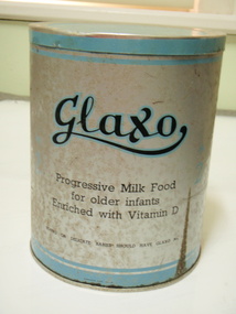
Container - Tin, Glaxo Laboratories, 1930's
... princes highway...Princes Highway, Port Fairy, South West, Victoria... for babies Glaxo factory princes highway manufacturer milk baby food ...Glaxo's Port Fairy Factory was built in 1929 as a milk factory it had a tin shop where the tins were manufactured and the milk was dried and sold as some of the first formula milk for babieslarge tin with printed information "Glaxo" progressive milk food for older infants enriched with Vitamin D Blue bands and silverGlaxo Progressive milk food for older infants enriched with Vitamin D Young or delicate babies should have Glaxo No 1. Table of quantities and directions for useglaxo, factory, princes highway, manufacturer, milk, baby food -
 Port Fairy Historical Society Museum and Archives
Photograph, Late 19th Century
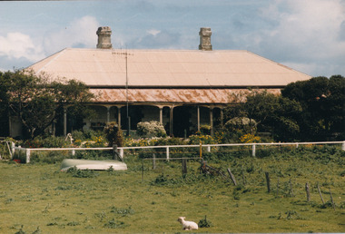
... princes highway...Princes Highway, Port Fairy, South West, Victoria... cottage princes highway Interior ..."Talara" sits on the hill on the outskirts of Port Fairy. It is one of 3 beautiful homes built in this vicinity. This was taken in the front drawing room.Black and Photograph of the interior of a room with a lady seated too the right of the windowtalara, 1895, house, building, cottage, princes highway, interior -
Port Fairy Historical Society Museum and Archives
Photograph
... princes highway...Princes Highway, Port Fairy, South West, Victoria... princes highway house home building Lattice fence Powell Remington ...Talara one of three large homes built on the hill. On the outskirts of Port FairyBlack and white landscape of 2 story house on hill with a lattice fence and four people leaning against fencetalara, princes highway, house, home, building, lattice, fence, powell, remington, rutledge -
 Port Fairy Historical Society Museum and Archives
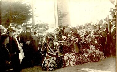
Photograph
... princes highway...Corner of Bank and Princes Highway, Port Fairy, South West... ceremony anzac soldier Memorial Bank Street princes highway ...Possibly taken on Anzac Day 1923 when the Memorial was finishedBlack and White Photograph of Anzac Day Soldiers Memorialevents, civil, ceremony, anzac, soldier, memorial, bank street, princes highway -
 Orbost & District Historical Society
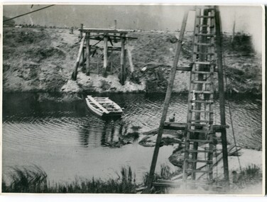
black and white photographs, 1915
... genoa-bridge princes-highway-east-gippsland... at this location. They provided crucial links in the Princes Highway route...on back - "Princes Highway - the 1st bridge over the Genoa.... on back - "Princes Highway - the 1st bridge over the Genoa River ...This photograph is of the construction of the first road bridge over the Genoa River - 1915. Before today's timber truss and concrete bridge was constructed between 1926-1928 by contractor J.T. Noble Anderson, two earlier bridges crossed the Genoa River at this location. They provided crucial links in the Princes Highway route from Melbourne to Sydney. The letter on the back of the postcard was written by Gordon ? to Alex ? on 2nd October 1917. "this represents the opening of Genoa Bridge. Mrs Alexander cutting the ribbon and Mr Martin holding it at the other side. Did most of the speaking. The gent holding the roll of paper is who came to open the bridge. I can't think of his name. Hubert is standing up at the right / Gordon " This is a pictorial record associated with the history of Genoa in East Gippsland.1100 -A large black / white photograph on a cream coloured buff card. It is of an unfinished bridge with men working there. A small rowboat can be seen on the far side of the river. 1100.1 - A photograph / postcard of the opening of "Genoa Bridge 1917". There is a ribbon stretched across the timber decking road in front of a group of people. 1100.2 - A black / white photograph of a road bridge across a river.on back - "Princes Highway - the 1st bridge over the Genoa River - 1915" on back of 1100.1 is a hand-written letter.genoa-bridge princes-highway-east-gippsland -
 Victorian Aboriginal Corporation for Languages
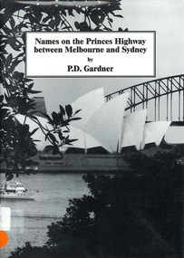
Book, P D Gardner, Names on the Princes Highway between Melbourne and Sydney : their origins, meanings and history, 2000
... Names on the Princes Highway between Melbourne and Sydney... Street Brunswick melbourne Book Names on the Princes Highway ...Place name list in a specific area. Giving descriptions and meanings.Maps, b&w illustrationsdandenong, genoa, south coast nsw, yarra river, moruya, kiama, captain cook, east gippsland, rosedale -
 Orbost & District Historical Society
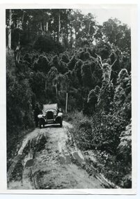
black and white photograph, 1924
... princes-highway-coolwater-creek green-oswald-stuart...on back - " O.S. Green 31 Malcolm St Blackburn Princes... Blackburn Princes Highway east of Coolwater Creek." History unknown ...History unknown. Oswald Stuart Green taught at the Bete Bolong State School in the 1920s /30s. He wrote many books about East Gippsland including several on thee Orbost / Marlo district.Oswald Green has an association with the Orbost area.A black / white photograph of a dirt road in the bush with a motor vehicle on the road and a man standing beside it.on back - " O.S. Green 31 Malcolm St Blackburn Princes Highway east of Coolwater Creek."princes-highway-coolwater-creek green-oswald-stuart -
 Warrnambool and District Historical Society Inc.
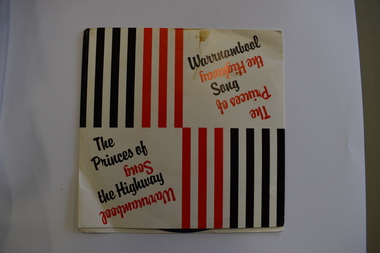
Audio - 45 R.P.M. Record, The Princes of the Highway, 1986
... The Princes of the Highway... of Warrnambool, 'The Princes of the Highway' and 'Warrnambool Song.... Record Audio The Princes of the Highway This is a 45 R.P.M ...This record features two songs about the city of Warrnambool, 'The Princes of the Highway' and 'Warrnambool Song'. The first-named is a reference to the fact that Warrnambool is on the Princes Highway and the 'princes' are those who grew and picked potatoes in times past. The lyrics are by a former Warrnambool resident, Camilla Fligelman and the singer is John Stevens. Warrnambool is a city in the western district of Victoria servicing an agricultural area, particularly the dairying industry. This record is of interest as one of several recordings made over the years celebrating the city of WarrnamboolThis is a 45 R.P.M. record with a red -coloured centre and black printing. It is enclosed in a thin cardboard envelope which has red and black lines and printing on the front and the lyrics of the two songs on the back.warrnambool songs -
 Port Fairy Historical Society Museum and Archives
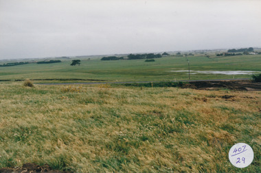
Photograph, Jock Varcoe, c.1980
... princes highway...South Beach Development looking toward princes highway... looking toward princes highway south beach development princes ...South Beach Development looking toward princes highwayColoured photograph of rolling hills and farmlandsouth beach, development, princes highway, farmland, swamp -
 Orbost & District Historical Society
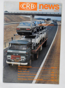
magazine, CRB News, August 1975
... magazine journal-crb-news princes-highway.... It contains an article on the Princes Highway, Gippsland.... is a road bridge. It contains an article on the Princes Highway ...The Country Roads Board was the government authority for the construction and maintenance of main roads in Victoria between 1913 and 1983. It was succeeded by the Road Construction authority on 1 July 1983 and later merged with the Road Traffic Authority on July 1 1989 to form the Roads Corporation. James Cameron, an Orbost farming pioneer and Member of the Legislative Assembly, fathered the Country Roads Board.This item is a useful research source on the Princes Highway, Gippsland.A 19 pp magazine, titled CRB ( Country Roads Board) News. It is dated August 1976. On the front cover is a coloured photograph of a truck carrying cars. In the background is a road bridge. It contains an article on the Princes Highway, Gippsland.magazine journal-crb-news princes-highway -
 Orbost & District Historical Society
black and white photographs, 25.11.1976
... Princes Highway, Orbost, East Gippsland, Victoria ...These photographs were taken on November 25, 1976 at the official opening of the current Snowy River road bridge. Included in the photographs are: John Duggan; Pat Hall, C.R.B. chairman, R.E.V. Donaldson (3240.7) and J.A.Rafferty, the state minister for Transport, who cut the ribbon (3240.8). Di Young and Cheryl Dusting (3240.9) distributed souvenir information pamphlets to official guests. The Snowy River road bridge is one of four built as part of the 8.4 km project spanning the Orbost flood plains. The Snowy River bridge and another over the nearby Ashbys Gulch are among the 10 longest bridges in Victoria, being the eighth and fifth longest respectively. The new bridge removed through traffic from Orbost township crossing the Snowy River 45 m downstream of the old bridge.This bridge is the fourth to provide a crossing to the township of Orbost. (info from CRB NEWS No. 34. DECEMBER, 1976) These photographs are pictorial records of a significant event in Orbost's history.Eleven black / white photographs all related to the official opening of the current Snowy River Bridge. Details are in catalogue folder.snowy-river-bridge -
 Warrnambool and District Historical Society Inc.
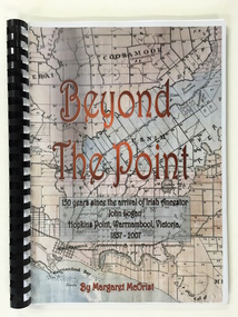
Booklet, Beyond the Point, 2007
... 64 Princes Highway, Port Fairy, Victoria, 3282 ...This book was written in 2007 by Margaret McOrist to mark the 150th anniversary of the arrival in the Warrnambool area of John Logan. It is a sequel to a 1991 book, ‘Clotted Cream and Mangels’ which told the story of John Logan and his wife Mary Gardner. They lived at Hopkins Point, Warrnambool and the book, ‘Beyond the Point’ tells the story of the Logan descendants. When the farm land was sub-divided and sold the nearby beach was named ‘Logans Beach’. This book is of considerable interest as it tells the story of the descendants of important early settlers, John Logan and Mary Gardner. The area where they first settled is now of major interest as Logans Beach (named for the Logan family) is the well-known whale watching area. Southern Right Whales return to this beach each year and the females calve and remain up to three months at this beach, making it an important ‘whale nursery’. This is a soft cover book with black plastic ring binding and clear plastic sheets covering the front and back paper covers. The front cover has a reproduction of an 1891 map of Warrnambool and district with the title of the book and other information superimposed on the map. The back cover is black. The book has 101 pages and contains information on the Logan families who lived at Tooram in Allansford and their descendants. There are many black and white and colour photographs, diagrams, maps and family trees. Front Cover: ‘Beyond the Point, 150 years since the arrival of Irish ancestor, John Logan, Hopkins Point, Warrnambool, Victoria, 1857-2007, by Margaret McOrist’. john logan and mary gardner, hopkins point, logans beach, tooram, history of warrnambool -
 Warrnambool RSL Sub Branch
Army Uniform, lanyard, Fletcher Jones & Staff, 1990s
... Corner Flaxman and Princes Highway, Warrnambool, Victoria ...Worn as part of a uniform, attached to the right shoulder of a jacket with the loose end in the right breast pocket. This jacket was worn by Bernie Farley, of the 8th/7th Battalion, Royal Victorian Regiment. This lanyard has social significance, being owned and worn by Secretary of the Warrnambool RSL, Bernie Farley. The lanyard was donated as part of a uniform set by Bernie Farley after 30 years of service in both the Australian Army and Royal Australian Air Force. Though worn in the 1990s, this uniform is in excellent condition as a representative example of an Infantry uniform of the period.Red cord lanyard with two loops knotted at either end; one knot has been looped around the lanyard to form an arm hole. The red colour signifies membership of the Australian Army.military uniform, ex-service, lanyard, army uniform, warrnambool -
 Warrnambool RSL Sub Branch
Army Uniform, lanyard, Fletcher Jones & Staff, 1990s
... Corner Flaxman and Princes Highway, Warrnambool, Victoria ...Worn as part of a uniform, attached to the right shoulder of a jacket with the loose end in the right breast pocket. This jacket was worn by Bernie Farley, of the 8th/7th Battalion, Royal Victorian Regiment. This lanyard has social significance, being owned and worn by Secretary of the Warrnambool RSL, Bernie Farley. The lanyard was donated as part of a uniform set by Bernie Farley after 30 years of service in both the Australian Army and Royal Australian Air Force. Though worn in the 1990s, this uniform is in excellent condition as a representative example of an Army uniform of the period.Brown and white candy-striped cord lanyard with two loops knotted at either end; one knot has been looped around the lanyard to form an arm hole. The striped colour signifies membership of the 8th/7th Battalion, Royal Victorian Regiment.military uniform, ex-service, lanyard, army uniform, warrnambool -
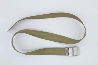 Warrnambool RSL Sub Branch
Army Uniform, belt, Fletcher Jones & Staff, 1990s
... Corner Flaxman and Princes Highway, Warrnambool, Victoria ...Worn as part of a uniform, this belt is to be worn around the waist with the tongue section on the wearer's right hand side. This jacket was worn by Bernie Farley, of the 8th/7th Battalion, Royal Victorian Regiment. This belt has social significance, being owned and worn by Secretary of the Warrnambool RSL, Bernie Farley. The belt was donated as part of a uniform set by Bernie Farley after 30 years of service in both the Australian Army and Royal Australian Air Force. Though worn in the 1990s, this uniform is in excellent condition as a representative example of an Army uniform of the period.Light khaki coloured woven belt with a pressed metal tip on one end and an autogrip style metal buckle on the other. Stamped into belt buckle "Lion Metal Goods"ex-service, military uniform, army uniform, warrnambool, belt -
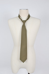 Warrnambool RSL Sub Branch
Army Uniform, tie, Fletcher Jones & Staff, 1990s
... Corner Flaxman and Princes Highway, Warrnambool, Victoria ...Worn as part of a uniform, by Bernie Farley, of the 8th/7th Battalion, Royal Victorian Regiment. This tie has social significance, being owned and worn by Secretary of the Warrnambool RSL, Bernie Farley. The tie was donated as part of a uniform set by Bernie Farley after 30 years of service in both the Australian Army and Royal Australian Air Force. Though worn in the 1990s, this uniform is in excellent condition as a representative example of an Army uniform of the period.Khaki tie with silk lining; tag attached to the reverse of the tie in the first quarter of the tie lenth. Label is sewn into seam on reverse. Label reads "AUSTRALIAN TIE CO./MADE IN AUSTRALIA", "65% POLYESTER/35% VISCOSE/MADE IN/AUSTRALIA", "DRY CLEAN/ONLY P50 [degree]/WARM IRON/USING INSERT."military uniform, ex-service, army uniform, warrnambool, tie, neck tie -
Port Fairy Historical Society Museum and Archives
Photograph
... Near Princes Highway , Orford, South West, Victoria ...the Horse and Jockey Hotel was built around 1856 for the purpose of providing rest, food and drink to the Bullockies travelling the stock route between Portland and Belfast. Hotel named so because the horse racing took place close by and the hotel was the jockeys official weigh in.A rare photograph of a hotel that no longer existsBlack and white photograph of the Horse and Jockey Hotel in Orford with two motor bikes in front with riders resting and large dog wandering across in frontOn Back in biro- Fred Toohey. Geoff Purcell in ink- Horse and Jockey Hotel Orfordhorse and jockey hotel, hotel, racing, orford -
 Port Fairy Historical Society Museum and Archives
Photograph, Clonmara Albert Rd
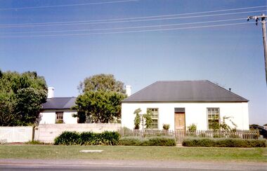
... Princes Highway, Port Fairy, South West, Victoria ...Coloured photographcottage, building, home, house -
 Port Fairy Historical Society Museum and Archives
Photograph, Comely Banks
... Princes Highway, Port Fairy , South West, Victoria ...coloured photographcomely banks, building, home, house -
 Port Fairy Historical Society Museum and Archives
Photograph
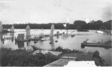
... Princes Highway, Port Fairy , South West, Victoria ...1946 was the year of the biggest flood experienced in Port Fairy. This photograph shows evidence of the inundation at the Port Fairy Cemetery situated at the West of the townBlack and white photograph of headstones surrounded by waterflood, river, 1946, headstone -
 Port Fairy Historical Society Museum and Archives
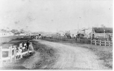
Photograph, c.1888
... Princes Highway, Heywood, South West, Victoria, Australia ...Street Scene Heywood c1888Black and white photograph of Post & rail fences children in foreground, buildings on right, cattle in far centre(Heywood),heywood, street, road, buildings -
 Port Fairy Historical Society Museum and Archives
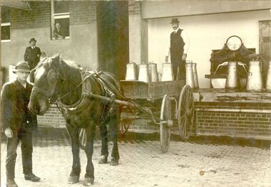
Photograph
... Princes Highway, Port Fairy, South West, Victoria ...Black and White Photograph of Horse and cart with milk cans being unloaded, weighed and emptied at factoryindustry, employee -
 Orbost & District Historical Society
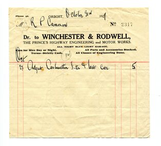
account, October 31st 1921
... Princes Highway, Orbost, East Gippsland, Victoria ...Winchester & Rodwell was an engineering and motor works opposite the Commonwealth Hotel in Orbost. It was the service station for General Motors products as well as the official R.A.C.V. service station. Robert Pullar Cameron was a Shire Councillor for many years. He married Penuel Hossack and had a family of James, Flora, Penuel and Alex.This item is an example of the book-keeping of an Orbost business in the early 20th century. It is a useful research tool.A white paper account with black print and red lines.It is from Winchester & Rodwell, Engineering & Motor Works to R.P. Cameron.account-book-keeping winchester-rodwell cameron,r.p. -
 Ballarat Heritage Services
Photograph - Digital photographs, L.J. Gervasoni, Kathleen Gervasoni at former Carleton Inn, Killarney, Victoria, 2015
... Princes Highway, Killarney, Moyne Shire, VIC, Australia ...Michael O'Dea, who built the Carleton Inn, was a member for the Belfast Road Board. Digital images of Kathleen Gervasoni at Carleton Inn, Killarney. She is the Great Grandaughter of Michael O'Dea who built the Inn.kathleen carroll, carleton inn, killarney, victoria, michael o'dea -
 Orbost & District Historical Society
black and white photograph, first half 20th century
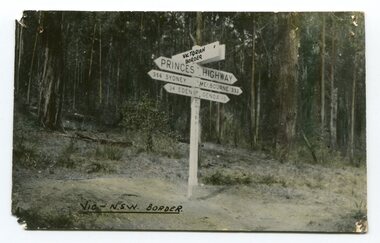
... Princes-Highway-East-Gippsland road-transport road-sign...Prior to the sealing of the Princes Highway west of Orbost... to the sealing of the Princes Highway west of Orbost, the road surface ...Prior to the sealing of the Princes Highway west of Orbost, the road surface was anything but good, even by C1917 when cars started to use the road. From Orbost the old road via Marlo to Sydenham was abandoned for the new location which traversed more rugged country via Cabbage Tree, Bell Bird and Club Terrace to Cann River, and the reason for this diversion was on account of settlements being established at Murrungowar and Club Terrace, at which latter place there was a temporary rush to obtain gold. This road was constructed by the Public Works department and a maximum grade of 1 in 19 was adopted, and as speed was not to be catered for the grade followed in and out round the spurs and gullies, resulting in a maze of turns and twists which required a good deal of skill on the part of the horse driver to negotiate." - Bairnsdale Advertiser, Friday, May 2, 1947. (More information from Newsletter February 2010)This is a pictorial record of an early road distance sign on a major highway through East Gippsland. The distances are indicated in miles, a measurement standard no longer in use.A black / white photograph postcard of the signpost at the Victorian - New South Wales border. It shows distances to Sydney and Eden on one arrow and distances to Melbourne and Genoa on another. on front - Vic - NSW Borderprinces-highway-east-gippsland road-transport road-sign -
 Orbost & District Historical Society
black and white photograph, 1924
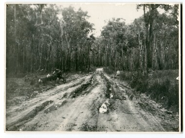
... road Princes-Highway Bellbird-Creek-1924... Gippsland, in 1924. This road would have been the Princes Highway... the Princes Highway, a main thoroughfare through to New South Wales ...This photograph shows the main road near Bellbird, East Gippsland, in 1924. This road would have been the Princes Highway, a main thoroughfare through to New South Wales. Bellbird Creek is a small rural location between Orbost and Cann River. There was no township at Cabbage Tree at this time. The Cabbage Tree Creek township was established to support the booming timber industry of the mid 20th century. Five timber mills worked full time supporting the families that were drawn to the area's wealth of natural resources. Nestled on the banks of the Cabbage Tree Creek, the township was built by those mills to house their workers. Today although the timber mills have disappeared, some of the buildings still remain. Little now remains to remind of the saw-milling history apart from photographs and some relics - a boiler and a brick furnace. There was also a thriving agricultural community farming dairy, beef, seed beans and fresh peas and beans that were sent to the Victoria Market in Melbourne. Dairy farming still plays an essential role in the township. this is a pictorial record of the Princes Highway, the main road from East Gippsland to the New South Wales border.A large black / white photograph of a very wet and boggy bush road.on front - "Main Rd near Bellbird 1924"road princes-highway bellbird-creek-1924 -
 Orbost & District Historical Society
black and white photograph, 1913
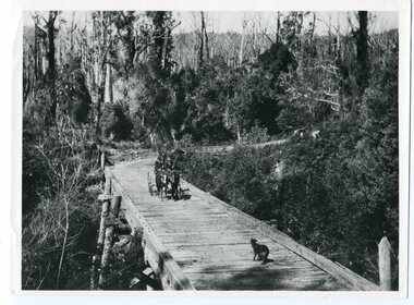
... on back - "Country Roads Board Princes Highway low level... - "Country Roads Board Princes Highway low level bridge ...This photograph is of the low level bridge across the Bemm River about 50 km east of Orbost in East Gippsland.This is a pictorial record of the 1913 low level bridge across the Bemm River, East Gippsland.A large black / white photograph of a horse - drawn wagon on the low level Bemm River bridge. In the foreground on the bridge is a dog.on back - "Country Roads Board Princes Highway low level bridge" -
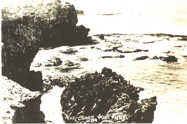 Port Fairy Historical Society Museum and Archives
Postcard, "The Crags", c. 1930
... princes highway... Fairy The crags- Circa 1930 the crags rocks sea ocean princes ...The crags- Circa 1930Photograph Rocky area with ocean waves washing over The crags Port Fairy the crags, rocks, sea, ocean, princes highway